PORTUGAL
OCTOBER/NOVEMBER - 2015
My expedition to Portugal this year started and ended with a trip through Spain as recorded in the preceding Post.

Please refer to that for a summary of the Iberian Peninsula's history including an account of the Moorish period and how Portugal freed itself from occupation by those invaders and Spain's evolving Kingdoms.
Here it is perhaps appropriate to note the background to the very long alliance between Portugal and England legalised by the oldest Treaty in the world that's still in force. For much of its duration it was of course fostered by a mutual dislike of Spain or outright hostility in times of war.
But the seed from which the alliance sprang was success in the Siege of Lisbon in 1147. In the summer of that year a group of English Knights on their way to Palestine to join the second crusade took refuge in Oporto from storms at sea. Whilst there they agreed to join the siege of Lisbon, still held at that time by the Moors, in exchange for a share of the pillage and ransom monies to be obtained after the city had fallen.
This co-operation created good-will on both sides but another 220 years passed before that flowered into the formal 1336 Treaty of Windsor.
A Period of Spanish Rule
To complete the historical picture it is worth explaining that for 60 years between 1580 and 1640 Portugal did become a vassal state of Spain even though it was never legally incorporated into Spanish territory and Spain didn't claim or exert sovereignty over Portugal's overseas territories.
This came about because the Portuguese Aviv Dynasty ran out of direct descendants from King Manuel I.
During Manuel's reign Portugal had become extremely wealthy as a result of Vasco da Gama's discovery of a sea route to India in much the same way that Spain later became ascendant after Columbus' discoveries in America.
Manuel married three times and had nine sons and four daughters so there were plenty of contenders for the Portuguese crown. But the direct line through which the monarchy passed on his death was first to his son Joao III followed by his grandson Sebastian and then through Joao's younger brother Henrique.
Henrique was a Cardinal of the church who was already 66 years old when he became King and died childless 2 years later thus precipitating a succession crisis.
Two contestants claimed the throne
- Antonio an illegitimate grandson of King Manuel whose father Luis, brother to Joao and Henrique, had already died
- and
- King Phillip II of Spain who was grandson to Manuel through his mother who was Joao's sister.
Phillip won that struggle but made no attempt to incorporate Portugal as a Spanish Province. Nor did his son King Phillip III but his grandson King Phillip IV did and the Portuguese nobility revolted acclaiming one of Manuel's great-great-grandsons King Joao IV.
This precipitated the so-called "Restoration War" that was mostly a matter of border skirmishing lasting 28 years ending in the 1668 Treaty of Lisbon in which Spain formally recognised Portugal as an independent Kingdom.
Since then Spain and Portugal have remained independent, albeit with several changes in types of Government including a phase within living memory when both were Fascist Dictatorships under Franco and Salazar respectively, now succeeded by a parliamentary form of democracy with Spain being a Constitutional Monarchy and Portugal a Republic.
ALANTEJO
After leaving Salamanca I crossed the border into Portugal just west of Badajoz entering the ancient province of Alentejo in which I stayed at three separate sites.
The first, simply called Alentejo on the map above lay between the town of Estremoz and village of Evora Monte

Unfortunately my photos of this area were lost in the 2016 computing disaster but I still remember them well so I'll have to make do with words.
This border region was heavily involved in the wars between the Portuguese and Moors and later with the Spanish. Most people in those times lived in fortified towns and Estremoz is a classic example of the type.
The town sits on the summit of a hill contained within massive 13th Century stone ramparts and has a castle with a high Keep at its centre. These were made from marble blocks quarried locally since Roman times.
Estremoz is still an important place for marble with current production of nearly 400,000 tons per year most of which is sold in world-wide export markets.
Evoramonte is even more dramatic. It is again built on the summit of a hill and has a castle at its centre with dwellings around, all enclosed within a massive wall. But the hill is much steeper with an escarpment on one side providing fine views over the plains to the west.
There is a modern village of Evoramonte at the foot of the hill but it is very small and has only a handful of houses and very little else. Beyond the main cluster of dwellings there was a small building with a Coca Cola sign outside. This had the local café in its basement where I had a very simple rustic supper one evening.
The region has many vineyards and I was very pleasantly surprised by the excellent quality and low price of the wines produced. Though much less well known than those of the Douro valley I preferred them for both flavour and economy.
ÉVORA
Évora is a much larger and older city than Estremoz built on top of yet another hill for defensive reasons. It was founded by the Celts more than 2,000 years ago.
The Romans conquered the town in 57BC and it became an important place at the centre of a wheat-growing district and the junction of two military roads.
A Roman wall was built to enclose and defend the town with baths and other buildings inside the walls. Some of these remains are still visible today as are the base and columns of a very impressive Temple believed to have been built in honour of Emperor Augustus.


Portuguese pronunciation of the letter V is rather like the English sound B in "bread" and after learning about the Roman occupation I was struck by the similarity between this city's name and that of the Roman name for York in England - Eboracum.
Sure enough it turns out that Ébora means -"of the Yew Trees"- in ancient Celtic and Eboracum - "Place of the Yew Trees" - so my inference of a connection was confirmed but it was a Celtic rather than a Roman one as I had suspected.
MARKADIA
Markadia is the name of a campsite rather than a town or village.
It lies on the southern shore of a large reservoir between the small towns of Alvito and Odivelas about 40km north east of Beja, the largest town in the area.


In addition to the usual site office there is a café/restaurant on a separate promontory perhaps 2 km away. Although that wasn't far it provided an opportunity for exercise by riding the bike there and back for lunch most days.
That accomplishment was put in the shade by Sean, another solo camper with a bike who rode often to Alvito and back for supplies. To meet my own needs I went to Beja by car a couple of times and found there everything I needed.
But the car developed a tremendous roar from the exhaust as the silencer rusted through. No problem getting it fixed as the site manager took me to the garage he uses in Alvito for inspection and ordering of new parts from Spain. The parts and fitting cost €800 which the garage owner said was all the entire car was worth in Portugal. Still, I didn't think the maintenance cost was excessive as it was the first time the exhaust had to be renewed after 21 years of ownership and nearly 90,000 miles.
Here's another view from the van taken in the early morning - the rabbits playing on the slopes must have seen some movement though because they had all disappeared by the time I operated the shutter.


The dryness hadn't seemed to affect the extensive Olive Orchards though and that too was a source of some regret. Apparently Spanish investors have bought large tracts of land in order to grow olives for oil - there was a large processing plant just outside Alvito.
The environmental change brought about by replacing natural scrubland with cultivated fields had apparently reduced the types and numbers of wildlife, particularly amongst bird species. The reservoir itself was said to attract some migratory wildfowl at the relevant times of year but whilst I was here I saw only huge flocks of Cormorants, apparently sheltering from storms at sea.
OURIQUE
The third Dutch-Owned site at which I stayed was a short distance south of Ourique Town near which the concluding battle of the Moorish wars was fought. The exact site of that battle is not known and there's no sign of its whereabouts now that's apparent to a casual visitor.
Sero da Bica campsite is situated on the steep northern slopes of the valley through which the Rio Mira flows.

Access to the site is down an extraordinarily steep and twisting gravel road generating some anxiety about whether one will succeed in towing a large van back up again with a regular 2xWheel drive car. (In the event I didn't have any trouble doing so).
There are many walking and hiking trails near this site but the hilly nature of the land, the thick vegetation and the traffic on the busy north-south IC1 road all deter one from doing much cycling.
The countryside is hot, stony and arid as can be seen in this photo and I got a strong feeling of being the sole inhabitant for miles around.

I did venture forth from the site a couple of times and rode up the hill on the main road to a minor turn off along a ridge that ultimately led to the site of a celebrated church near an old Moorish fort.
I was more interested in the latter although all that's now left are parts of the enclosing walls and low foundations of the parade ground, stabling and other buildings within them. The notice explained there had been a fort here for over a thousand years and the Moors had adapted and extended earlier fortifications some 500 years after the Romans had left.


This border region was heavily involved in the wars between the Portuguese and Moors and later with the Spanish. Most people in those times lived in fortified towns and Estremoz is a classic example of the type.
The town sits on the summit of a hill contained within massive 13th Century stone ramparts and has a castle with a high Keep at its centre. These were made from marble blocks quarried locally since Roman times.
Estremoz is still an important place for marble with current production of nearly 400,000 tons per year most of which is sold in world-wide export markets.
Evoramonte is even more dramatic. It is again built on the summit of a hill and has a castle at its centre with dwellings around, all enclosed within a massive wall. But the hill is much steeper with an escarpment on one side providing fine views over the plains to the west.
There is a modern village of Evoramonte at the foot of the hill but it is very small and has only a handful of houses and very little else. Beyond the main cluster of dwellings there was a small building with a Coca Cola sign outside. This had the local café in its basement where I had a very simple rustic supper one evening.
The region has many vineyards and I was very pleasantly surprised by the excellent quality and low price of the wines produced. Though much less well known than those of the Douro valley I preferred them for both flavour and economy.
ÉVORA
Évora is a much larger and older city than Estremoz built on top of yet another hill for defensive reasons. It was founded by the Celts more than 2,000 years ago.
The Romans conquered the town in 57BC and it became an important place at the centre of a wheat-growing district and the junction of two military roads.
A Roman wall was built to enclose and defend the town with baths and other buildings inside the walls. Some of these remains are still visible today as are the base and columns of a very impressive Temple believed to have been built in honour of Emperor Augustus.

Évora Roman Temple
The Moors conquered the city and surrounding countryside in 715 and stayed in possession for 450 years until they were evicted by Gerald the Fearless in 1165. Gerald was the Portuguese predecessor to El Cid of Burgos and was initially successful in capturing other cities farther north and east. This was seen by Ferdinand the King of Leon as an encroachment on territory belonging to him.
At the time Ferdinand was allied with Yusuf, the North African claimant to the Caliphate, who also governed Islamic Iberia. So Gerald found himself fighting both Moors and Leonese at the same time and was captured by the Leonese to whom he ceded several of the cities he had won to secure his freedom.
Gerald's colourful career continued thereafter, changing allegiance from his Portuguese King to Yusuf and back again whereupon he was put to death for plotting a Portuguese invasion of Southern Morocco. They did have exciting lives in those days.
But Évora remained in Portuguese hands after Gerald's success there, was not recaptured by the Moors, and became an important centre of commerce and learning during medieval times.
It was in the latter period that a University was founded, a new city wall built together with a Cathedral (whose roof can be visited to obtain a bird's eye view of the city and surrounding countryside) and a famous aqueduct bringing fresh water to the city from a river 9km to the north.

Évora Cathedral

Medieval Agua de Prata
Sure enough it turns out that Ébora means -"of the Yew Trees"- in ancient Celtic and Eboracum - "Place of the Yew Trees" - so my inference of a connection was confirmed but it was a Celtic rather than a Roman one as I had suspected.
MARKADIA
Markadia is the name of a campsite rather than a town or village.
It lies on the southern shore of a large reservoir between the small towns of Alvito and Odivelas about 40km north east of Beja, the largest town in the area.

The site here was on a large tract of land bought from the local commune many years ago by the Dutch family who still own and operate it (Alentejo seems to be a magnet for Dutch campsite owners - all three sites in the Province at which I stayed were developed, owned and operated by expatriate Dutch couples - one benefit for the camper is that all three were well equipped and scrupulously maintained).
Many of the pitches at Markadia have splendid views over the reservoir such as this one taken from the side of my own van.

Prospect from my Pitch
That accomplishment was put in the shade by Sean, another solo camper with a bike who rode often to Alvito and back for supplies. To meet my own needs I went to Beja by car a couple of times and found there everything I needed.
But the car developed a tremendous roar from the exhaust as the silencer rusted through. No problem getting it fixed as the site manager took me to the garage he uses in Alvito for inspection and ordering of new parts from Spain. The parts and fitting cost €800 which the garage owner said was all the entire car was worth in Portugal. Still, I didn't think the maintenance cost was excessive as it was the first time the exhaust had to be renewed after 21 years of ownership and nearly 90,000 miles.
Here's another view from the van taken in the early morning - the rabbits playing on the slopes must have seen some movement though because they had all disappeared by the time I operated the shutter.

Rural Tranquillity
Markadia is only about 100 miles north of the Algarve Coast and shares the same benign climate. One or two camping couples said they returned for several months each year as they preferred the peace of this place to the "Compulsory Games" of the busier sites on the coast where large numbers of retired expatriates tend to gather for a winter in the sun.
The water level was very low when I visited and locals were hoping for more rain in the New Year to preserve supplies and irrigate the fields.

Water's Low
The environmental change brought about by replacing natural scrubland with cultivated fields had apparently reduced the types and numbers of wildlife, particularly amongst bird species. The reservoir itself was said to attract some migratory wildfowl at the relevant times of year but whilst I was here I saw only huge flocks of Cormorants, apparently sheltering from storms at sea.
OURIQUE
The third Dutch-Owned site at which I stayed was a short distance south of Ourique Town near which the concluding battle of the Moorish wars was fought. The exact site of that battle is not known and there's no sign of its whereabouts now that's apparent to a casual visitor.
Sero da Bica campsite is situated on the steep northern slopes of the valley through which the Rio Mira flows.

Looking towards the Rio Mira
Access to the site is down an extraordinarily steep and twisting gravel road generating some anxiety about whether one will succeed in towing a large van back up again with a regular 2xWheel drive car. (In the event I didn't have any trouble doing so).
There are many walking and hiking trails near this site but the hilly nature of the land, the thick vegetation and the traffic on the busy north-south IC1 road all deter one from doing much cycling.
The countryside is hot, stony and arid as can be seen in this photo and I got a strong feeling of being the sole inhabitant for miles around.

Do you feel you're a stranger in a strange land?
Its hard to imagine there can be much productive agriculture here but there were many signs indicating these hills were used for Hunting - but no sign of what the prey might be.
I was more interested in the latter although all that's now left are parts of the enclosing walls and low foundations of the parade ground, stabling and other buildings within them. The notice explained there had been a fort here for over a thousand years and the Moors had adapted and extended earlier fortifications some 500 years after the Romans had left.

A Moorish Hilltop Castle
I had an unusual and somewhat unpleasant experience when returning from this ride as I detoured through a very small village bypassed on the outward journey.
It was hot and without a breeze or any sign of human life as I rode slowly up a shallow slope past a number of low dwellings. But outside each building were large numbers of dogs lazing in the sun.
As I went slowly past, first one, and then another, and another, and another ....... came out to start barking and snapping at my heels until I ended up pedalling harder and harder to escape from the pack around me. I wondered if the prey hunted on these hills could possibly be strange men and if I had become one of them!
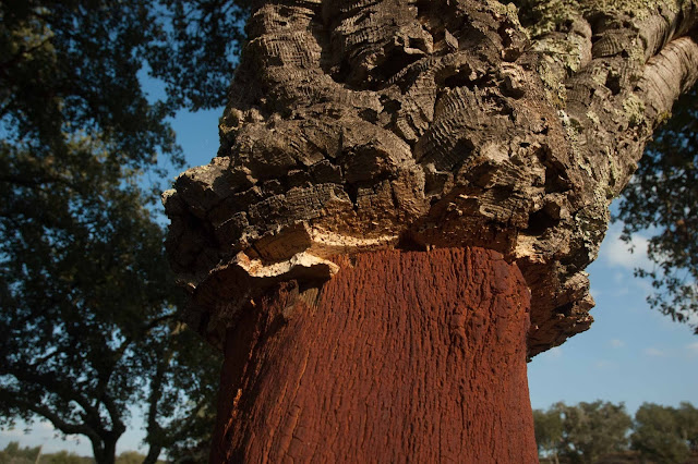
The production and sale of Cork has long been one of Portugal's most important trades - the country provides about 50 % of worldwide production. Cork is impermeable, buoyant, flame-resistant and light. These properties make it suitable for all sorts of uses from bottle stoppers to spacecraft insulation.
Cork is the bark of a special type of oak tree - smaller than the English Oak but growing prolifically in the soils and climate of southern Portugal - particularly in Alentejo Province.
But, it is slow-growing and requires a great deal of manual labour to harvest as it must be cut from the tree using an axe. A cork oak needs to grow for about 25 years before it can be harvested and thereafter can only be stripped of its bark once every 12 years. But the trees are long-lived and continue to produce until they're about 200 years old though the average age of those currently in production is estimated to be about 80.
The development of plastic and aluminium stoppers for wine bottles over the last ten years or so reduced demand for cork but the war is by no means over with cost and environmental impact being the continuing fields of battle - cork harvesting is regarded as an entirely sustainable activity as it is naturally renewable and doesn't harm the trees or require frequent replanting.
Most cork is produced from estates dedicated to the purpose but property owners with trees in their grounds can also benefit from the market. Here are a couple of pictures of one on the campsite near Ourique.

Harvesting Cork from an Oak Tree

SAGRES
King John I of Portugal was the first monarch of the Aviv Dynasty and won the crown in 1385 after an interregnum during which an earlier dynasty ran out of male heirs ( a fate that was to befall John's own family 200 years later).
John had nine children by his first wife Isabella who was a daughter of John of Gaunt, Duke of Lancaster sometimes called "Kingmaker" and the alliance between Portugal and England was clearly in full swing in his time.
John's fifth child and third son became famous as "Henry the Navigator" acknowledged to be the patron of efforts culminating in development of the lateen-rigged caravels that could sail to windward and the early stages of Portuguese exploration in which they charted the African coast, discovered the Madeiran and eastern Azores islands and so on.
John appointed his son at age 25 to be Governor of the Algarve and it was in that capacity Henry became interested in developing a better type of boat than those available hitherto, largely to combat Barbary pirates who frequently raided his coast and captured its inhabitants to sell in the African slave markets.
Henry was never an active sailor or navigator himself but in addition to fighting pirates he was keenly interested in going farther south than the African territories controlled by the Berbers in an effort to locate the source of gold brought by traders to the coastal towns opposite his own territory.
It was with this objective, at least initially, that he sponsored many of the voyages of exploration possible now caravels could sail farther and faster than Europeans had gone before.
It was through these voyages that systems of prevailing winds and currents became understood and used - for example the all-important discovery of a method of returning to Portugal from the Atlantic by first sailing west and north before turning east to catch the wind in higher latitudes.
The discoveries made during these early voyages were succeeded by many others, of both discovery and colonisation, first by the Portuguese - in and across the Atlantic, finding a sea route to India etc, then by the Spanish, Dutch, French, English and so on.
One of Henry's accomplishments was to establish a School of Navigation at Sagres in the south western corner of the Algarve where he frequently lived and ultimately died in 1460.
I had sailed past this area in Alchemi in 1998 on her way to Madeira and the Canary Islands before crossing the Atlantic in 1999 but had not made landfall until reaching Lagos. So one of my objectives in 2015 was to visit the remains of Henry's School.
I was able to attempt that by riding my bike from a municipal campsite amongst some pine trees not far from Sagres town. The site was rather basic and not so well serviced and maintained as the Dutch owned ones I'd stayed at hitherto. But it was in a convenient location for my purposes.
The peninsulae on which Sagres and Cape St Vincent are located have 60 metre high cliffs with the fairly flat land away from the coast mostly covered with wind-swept coarse vegetation and a few clumps of pine trees.
There is a Lighthouse that can be visited at Cape St Vincent with car parks and refreshment stalls lining the approach road - not unlike Land's End in England or any other remote place at the edge of a land mass. Henry had a private residence where the lighthouse now stands but there are no remains to be seen.
Sagres Point is the name given to the tip of a thin promontory at Sagres on which the "Fortaleza de Sagres" now stands.
It was on this site that Henry organised his "School". I have put School in inverted commas because it is doubtful if there was ever a physical presence beyond basic accommodation and a small church dedicated to Santa Maria (replaced after Henry's time with the still standing "Church of Our Lady of Grace").
Inside the present fort there is a large diameter circle with compass points marked upon it that is said to have been used by Henry and his contemporaries - but I have to say it didn't seem particularly useful as an educational tool and I have to wonder whether there isn't quite a lot of marketing imagination in references to it.
The extant Fortaleza was built in the 16th Century and restored in the 20th after years of neglect following severe damage in the 1755 Lisbon Earthquake. There are some fortifications in the interior and gun emplacements for cannon protecting the seaward approaches but its strength rests primarily upon a massive wall with further gun emplacements placed across the narrowest part of the promontory separating the remainder from the landward side.
So the visit was mildly disappointing because of the paucity of physical remains but one could imagine Henry, surrounded by his sea captains, cartographers and others hearing reports of the latest voyage and refining their understanding of the Geography, winds and currents of the Atlantic Ocean and African coast.
Nowadays the area is popular with surfers who ride the Ocean waves before they crash on the beach at the foot of the cliffs.

Looking towards Cape St Vincent from Sagres Point
ALBUFEIRA
The campsite at Albufeira is large with all the usual facilities and is very popular with UK expatriates many of whom stay for the winter months.
The town itself is a very busy seaside resort with abundant hotels, restaurants, and shops densely built above and down the steep, almost cliff-like hills to the rather small beaches and water's edge entertainments below.
The climate is benign with plenty of sunshine and I'm sure its fine for those who like this sort of thing but I enjoyed it less than the quieter and more historically interesting places farther inland, and less than my next stop in north-west Andalusia described in the preceding Post).
No comments:
Post a Comment
Note: only a member of this blog may post a comment.