UK
- SOMERSET
MAY
- 2016
PRIDDY
CAMPSITE AND VISITS THEREFROM
THE MENDIP HILLS
The Mendip Hills rise about 150m from sea level and
extend roughly 25km from East to West and 5 km north to south.
At their western end they terminate in Brean Down that is a
peninsula pointing like a finger across the estuary of the River
Severn towards South Wales, and at their Eastern end they decline
towards Salisbury Plain near the small town of Frome. Two
extensions to the line of hills form the islands of Steep Holm and
Flat Holm roughly half way across the Estuary.
The Mendips were formed by limestone deposits from an
ancient seabed being laid down over even older sandstone and later
upheavals of the earth's crust. Over many millenia much of
the limestone was worn away at the highest point so now the sandstone
lies very near the surface along the uppermost ridge with limestone
all around its edges.
Because water just runs off sandstone but dissolves
limestone this has resulted in deep gorges and many caves around the
dges of the hills. Human and anaimal rermains from some
12,000 years ago have been found in some of them.
NEARBY
TOWNS
There are many small villages and some larger towns on
and around the Mendips. Notable amongst these are the seaside town
of Weston-super-Mare where I grew up, Wells which is the smallest
Cathedral City in England where the Bishop has a moated Palace, and
Cheddar famous the world over for the cheese that bears its name but
was first made here centuries ago.
Not far away is the town of Glastonbury, famous for the
tower (called a "Tor") on the summit of its small hill that
nevertheless stands tall above the surrounding Sedgemoor marshland.
Glastonbury has been a town since well before the Birth of Christ
and legend has it that Joseph of Arimethea visited and struck his
staff into the ground whereupon it subsequently grew into a living
tree. Legend also tells King Arthur's Camelot was founded here
though it has to be said many other places also make a similar claim.
Nowadays Glastonbury is well known for the music festivals held
here to which thousands of people come and camp to listen to rock and
pop bands.
Priddy is a tiny village high in the hills above Cheddar
and has a campsite at which I stayed between the 14th and 23 May
2016.
PRIDDY CAMPSITE
The site is run by a couple who are Franchisees of the
Camping and Caravanning Club to which I belong and claims to have 90
pitches. But during my stay there must have been a shifting
population of fewer than half that number.
So it was well appointed and quiet. Furthermore,
because I had booked to stay longer than most I was assigned a pitch
at the edge of the site overlooking farmland in general and a field
in which horses grazed and galloped in particular. Here is a
photo of my outlook.

The camp shop had locally made cheese for sale and the
farm next door also sold beef and other eatables from free range
animals they had raised themselves. You can be sure I tried both
and felt I was living well away from modern mass marketing.
I can put my bicycle inside my new car without having to
take it apart so I was able to make a few trips - sometimes just in
the car and sometimes using the car for the main journey but getting
the bike out to have a ride when I reached an attractive spot -
though there are many more people, roads and houses in comparison
with conditions when I was a boy.
Here are notes and photos of some of the places I
visited.
CHARTERHOUSE
Charterhouse is even smaller than Priddy with just a
couple of farmhouses now.
But it wasn't always like this. People have lived
here since the Stone Age and it was an important stop during the Iron
Age for people travelling from their fort on Brean Down to the much
larger one at Old Sarum near modern day Salisbury - a distance of
about 150 km. Doesn't sound far these days but imagine
walking it with bears, wolves and wild enemies seeking prey as you
trudged along the route!
The hamlet became important in Roman times soon after
the new Millenium when they first colonised Britain. That was
because they found lead and silver ore here where it was easily mined
as it was near the surface. All the silver was soon extracted
but lead mining continued on and off until the nineteenth century.
The area is now designated as an area of special
scientific and environmental interest. Here's a photo showing some
of the old workings that are of course now completely grassed over.

Ancient Lead Mines
I have a special memory of this place from when I was
eleven years old in 1947.
At the time I was a keen boy scout and my father and the
Assistant Scoutmaster of the Troop to which I belonged (his name was
Pip) conceived the idea of making the journey to Old Sarum along the
same route travelled by the Ancient Britons.
So, at Easter, we set off with bulging rucksacks full of
tents, sleeping bags, cooking pots, stoves, and other camping gear. But we didn't start at Brean Down because there were many
modern houses, roads and so on for the first part of the journey. Instead we were taken by car to a farmhouse not far from the lead
mines at Charterhouse where we were given permission to camp in one
of the farmer's fields.
Soon after pitching the tents and crawling into our
sleeping bags we heard a quite loud pitter-patter on the tent
material - but it wasn't enough to require investigation or stop us
from dropping off to sleep.
Awaking in the morning and looking out we saw it
hadn't rained the previous evening - we had heard the noise of
snowflakes landing on the thin material of the tent roof. Snow now lay six inches deep for as far as we could see in all directions.
So that expedition was abandoned and we never did do any
serious hiking in the steps of the Ancient Britons.
There was no snow in May this year but in the cooler air
on the hills there were still a few bluebells colouring the
landscape.

Bluebells in May!
BURRINGTON COMBE
The word Combe, pronounced coom, is derived from the
ancient Celtic meaning "steep-sided valley". It is found
in many parts of Great Britain in one form or another - for example
in Wales it is spelt Cwm. Because the sport of mountaineering was first practised
in Great Britain the same word has been exported to many other parts
of the world - for example a valley high on Mount Everest is known as
The Western Cwm.
So, Burrington Combe is narrow with steep sides and has
at its bottom a twisting road - somewhat similar to Cheddar Gorge but
with cliffs that are less high and dramatic.
Like Cheddar Gorge though it does have several caves
with evidence of pre-historic occupation and is popular amongst
speliologists. As a teenager I tried it here once but didn't like it very much at all - squeezing through narrow
crevices, not knowing whether one could squeeze back, coming across
vertical drops and wondering if one would be drowned if there was a
sudden downpour! It struck me rather like rock-climbing in the
dark only worse!
But Burrington Combe is well known for another reason
illustrated by this photo.

Rock of Ages
In 1762 while out for a walk, the Reverend Toplady
was caught in one of those downpours so common in this part of the
country. He took shelter in this crevice under the overhanging
stone. This inspired him to compose the well-known hymn "Rock
of Ages, Cleft for me, ...."
WESTON-SUPER-MARE
Weston was a small hamlet or village for centuries until
the late 1800's when it blossomed as a seaside resort. It is scarcely a proper seaside because it is on the
south eastern bank of the River Severn as it widens to several
kilometres between the English and Welsh coasts. But, it is tidal, it does have extensive sands and it is
the closest such place to Birmingham which was the centre of
Britain's industrial heartland at the time.
My parents lived in the much larger and well-established
city of Bristol about thirty km up-river from Weston and I was born
there myself in 1936. But in 1940 there were many German
air-raids on Bristol and its docks at Avonmouth so my parents decided
to rent a house in a hamlet called Holcombe not far north of Priddy. We lived there until 1942 when the family moved to
Weston because my father still worked in Bristol and the daily
journey was much easier than it had been from Holcombe.
So, I lived in and went to school in Weston between the
ages of 6 and 18. I have far too many memories to write about now but it was interesting
going back to Sand Bay the other day - where I heard my first cuckoo
of the year - seeing the old pier at Birnbeck and the rocks at Anchor
Head on which I used to play.

Birnbeck Pier now needs major renovation if it is to survive
Interesting too to pass the greens between the Sea Front
and the parallel road inland on which I remember massed US military
vehicles being assembled in readiness for the Normandy Landings during WW II.
The southern end of the Promenade was a favourite place
of mine for many years upon becoming 11 years old. That was the
year when the family visited London after an abortive attempt to
follow the trail of the Ancient Brits. It was notable from my
point of view because my father took me to Selfridges Store in Oxford
Street and there we found the first roller skates available after the
war.
They were pretty basic by today's standards with steel
wheels that soon wore "windows" on the rolling surface. They made a tremendous racket, but the skates did have rubber bushes so a degree
of directional control was possible. I loved them and spent all
my spare time on the 1/4 mile section of the Promenade allocated for
skating where we used to play tag zooming in and out of wind
shelters and all over the available space.
The glass sided wind shelters are still there but this
is a photo of the ones integrated into the sea-wall that sometimes
used to trip us into a headlong fall onto the sands below.

Birnbeck and New Piers seen across the sands
These were the sands upon which my father and I were
swept ashore one Boxing Day after a maiden voyage in a canoe he had
rebuilt as a Christmas present. We managed famously when facing the waves on the way out
to sea but were rolled completely over when sideways-on as we tried
to turn back to shore. The rise and fall of tide here is the
second highest in the world so we also had to push the upturned canoe
ahead of us whilst struggling through knee deep glutinous mud before
reaching the dry sands.
Perhaps most evocative of all was passing 7 Malvern Road
at which I had been revived with milky tea containing a shot of
brandy after running a mile in clothes sopping wet with muddy
seawater!
In this house too I had cowered one night under a
Morrison Shelter like the one in the pic below as returning German
bombers dropped off explosives they'd not been able to aim at their
designated targets. One landed in a railway embankment at the
bottom of our garden but fortunately it didn't explode.

A Morrison Shelter
The shelter also served as a dining table when the sides
were removed and on ours my parents and three uncles in the airforce
played monopoly when they could get an evening pass from the Locking
camp near Weston. They weren't posted to Locking for long but I
always remember them complaining about the camp food. That was
perpetually bad as the camp was also a training centre for RAF cooks.
Trainees were always moved on as soon as they could produce
anything edible so other airmen in the camp were always fed by
beginners.
Unsurprisingly my old school - the Weston-Super-Mare
Grammar School for Boys, and its sister establishment for girls, -
have long gone and the site is now occupied by a sixth form college
specialising in Mathematics.
BREAN DOWN
This peninsula was occupied for centuries before the
Birth of Christ and there was an Iron Age fort at the landward end.
Also at the landward end and just north of the peninsula
itself is the mouth of the River Axe at a place now called Uphill. This is an abbreviation of Hubba's Pyll. Hubba was a raiding
Viking and Pyll was the Viking word for harbour so the place he
landed his longboat was naturally named after both him and the use to
which he put the river entrance.
There was a great scare in the middle of the 19th
century because the French had designed and built an iron-sided
warship at a time before the British had done the same and were still
reliant upon wooden vessels.
The British Government feared an invasion up the Severn
Estuary and so built three forts in which they mounted large guns
capable of firing shells at any ship anywhere across the width of the
estuary. One was sited on the Welsh coast, one on the island of
Steep Holm and one at the tip of Brean Down.
No invasion was ever attempted so the guns were removed
and the buildings converted to tearooms and souvenir shops in the
early 1900's when Weston bloomed as a seaside resort. During the
second world war the Military again took over the site that was used
to mount powerful searchlights and as a station for developing
experimental weapons systems.
One idea was to develop a bouncing bomb similar to the
ones successfully used in an air attack on the dams in the Ruhr
Valley. In this application the notion was to mount them on a
trolley that would be launched downhill on a pair of rails and then
brought to an abrupt stop by buffers at the end. The idea was that the bomb would be projected off the trolley and skip over
the surface of the sea until hitting its target.
But in practice it was found so much momentum was built
up that trolley and bomb burst through the buffers and the whole lot
went over the cliff and straight into the sea. In the lower right of this photo
you should be able to see the rails on which this happened.

Power of the Sea and the Bomb that Didn't Bounce
The photo also illustrates the height and power the sea
can develop in these parts. The building was designed to house one
of the searchlights and had a projecting fringe to stop light from
shining upwards. You can see the fringe has been
torn off the rest of the roof and flipped backwards upon it.
Climbing up to the Brean Down ridge and cycling along it
was the first expedition I made when I bought my new bike in 2012. I repeated that journey this week though less speedily as another
4 years and loss of fitness has slowed me down more than a little.
Still,
I made it and was rewarded with some good views of Weston Bay
including this one in which a seagull was flying fast enough to beat
the camera shutter speed.
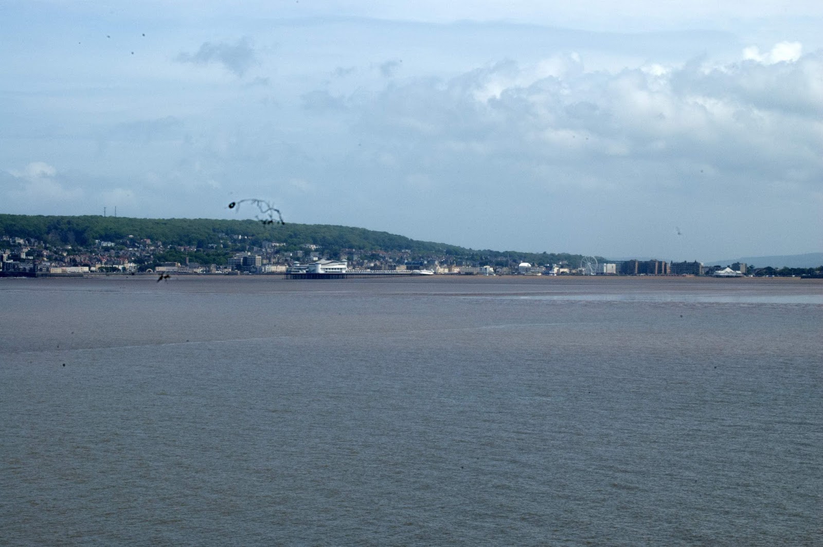
Weston from Brean Down
No comments:
Post a Comment
Note: only a member of this blog may post a comment.